
Climatology Analysis Over the Eastern African Region
Published:
Authors: Joy Pamela Kina Kariuki, Origene Tuyishimire and Yusuf Brima
Introduction
Climate has been a global topic for the past decades and one of the eminent existential threats for modern civilisation due to climate change. The industrial revolution has been one of the primary catalyst to increase the global carbon footprint, greenhouse emission, halogens such as chlorofluorocarbon amongst other non-anthropomorphic climate forcings. These activities has steadily led to wide spread changes in climatic conditions such as global temperature, sea levels, precipitation, and other indicators. According to the Intergovernmental Panel on Climate Change (IPCC) [1] (the United Nations body for assessing the science related to climate change),it certain that, in most places temperature will continue to rise. Therefore, the rise of global temperature will have cascading and feedback effect on other processes that contribute to climatic conditions.
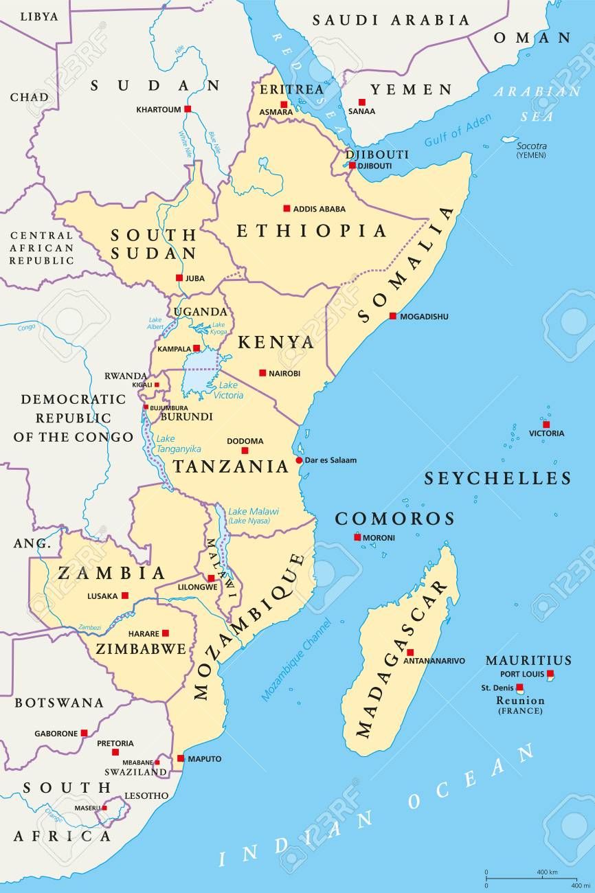
In light of this, it is vital to understand the climate patterns of different regions especially in sub-Saharan Africa, primarily to have more specific, detailed and valid information to inform policy and help in preparedness of extreme events. Africa, has an equatorial climate, tropical wet and dry climate, monsoon climate, semi-arid climate, desert climate and the subtropical highland climate. Due to this, different regions vary in the amount of precipitation and the temperatures. East Africa is in the eastern part of Africa. It mainly experiences a tropical climate due to the equator. The region has low altitude areas and high altitude areas which makes the weather patterns vary. This study focuses on the climatology of East Africa with a focus on the precipitation and temperature, mean and their seasonality as well as the dryness and wetness conditions in the region. The figure [1] below shows the map of the East Africa region, the principal geographic area of study with a special interest in Kenya.
Kenya is a country in East Africa that lies along the equator. It has 7 climate regions in the different geographical regions such as high altitude areas as well as the low altitude areas. Due to this, the temperature varies from cool to hot depending on the altitude of the area. The physical geography also greatly affects the rainfall patterns and the amount of rainfall received. The high altitude areas such as the central part of the country receives high rainfall. The coastal area, which is a low altitude, experiences hot and wet climate conditions. The northern part which is the Semi-arid, is adversely affected by dry conditions and very high temperatures.
Data and Methodology
Data In this report, we utilised two archive dataset (chirts_Africa_masked.nc and chirps-v2.0.1985-2004.days_p25.nc ) from the Climate Hazards Group, the University of California at Santa Barbara [2]. The gridded convective precipitation (measured in mm/day) ranges from 1985-01-01 to 2004-12-31 at a daily interval with 7305 timesteps. The Climate Hazards Center Temperature Maximum (Tmax measured in degree Celcius) range from 1983-01-01 to 2016-12-31 at daily intervals with 12444 timesteps. Both climatological datasets follow the NetCDF Climate and Forecast (CF) 1.6 metadata conventions.
Methodology To help understand the underlying climatology including seasonal conditions (i.e., mean precipitation, Tmax, wetness and dryness) over eastern Africa with a focus on Kenya, we have used Climate Data Operator (CDO), which is a collection of command-line Operators to manipulate and analyse Climate and Numerical Weather Prediction (NWP) model data [3] and Python programming Language with its helper libraries for visualisation. We computed the mean precipitation and maximum temperature at both regional and country levels to help provide fine-grain climatic processes over the time frames in both datasets.
Results and Discussion
Mean climatology
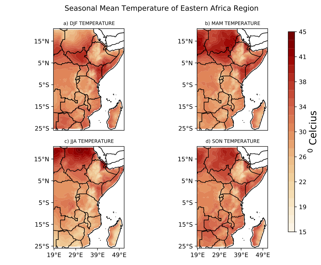
The figures below show the mean temperature experienced in East Africa as well as temperature in the four different seasons.
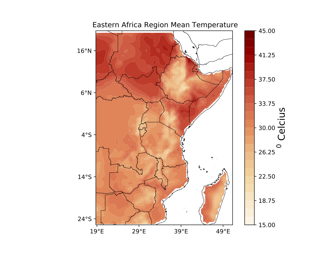
The Figure [2] above shows the distribution of mean temperature across East Africa. The figure above shows high temperature being experienced in the northern part of Kenya, Somali, parts of Ethiopia, Eritrea and South Sudan. These are relatively hot areas. Most of the countries in the Southern parts of East Africa, such as Tanzania, Rwanda, Burundi and Mozambique experience average temperature throughout the year. On average, most part of Kenya experiences high temperatures especially in the North Eastern as it can be seen. The central and the western side experience the lowest temperature in the country.
The figure for seasonal temperatures shows the different seasons of East Africa which are DJF, MAM, JJA and SON seasons. Looking at the maps, we can identify similarities in the amount of temperature experienced in East Africa during DJF, MAM and JJA seasons. The Northern part of East Africa including South Sudan experience relatively high temperature which is above average. However, during the SON season, most parts of East Africa experience above-average temperature. This means that most parts of East Africa are relatively hot throughout the season. The hottest region being South Sudan, the northern part of Kenya and Somalia. Few regions such as some parts of Ethiopia experience below-average temperature. In Kenya, north eastern region leads in all the seasons with the highest temperatures. The central and western side records the lowest temperature in the country.
Mean Precipitation
The figures [4] and [5] below show the mean precipitation experienced in East Africa over 20 year period as well as precipitation received in the four different seasons.
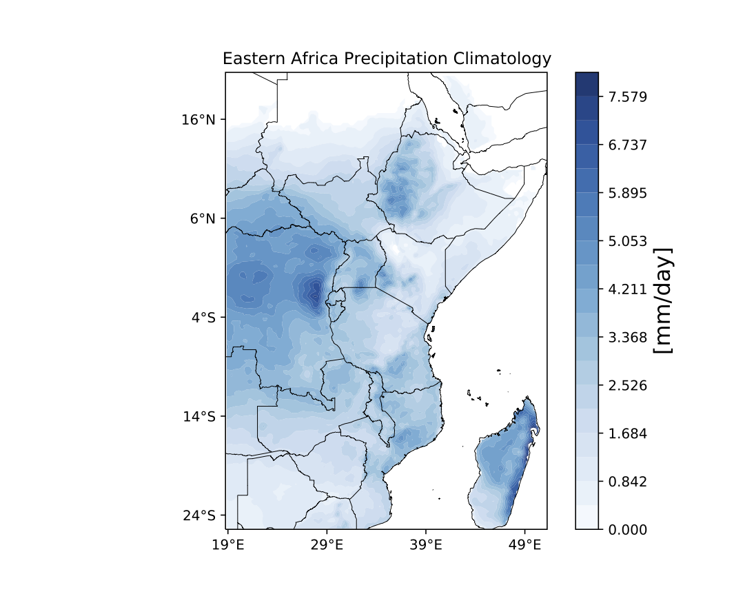
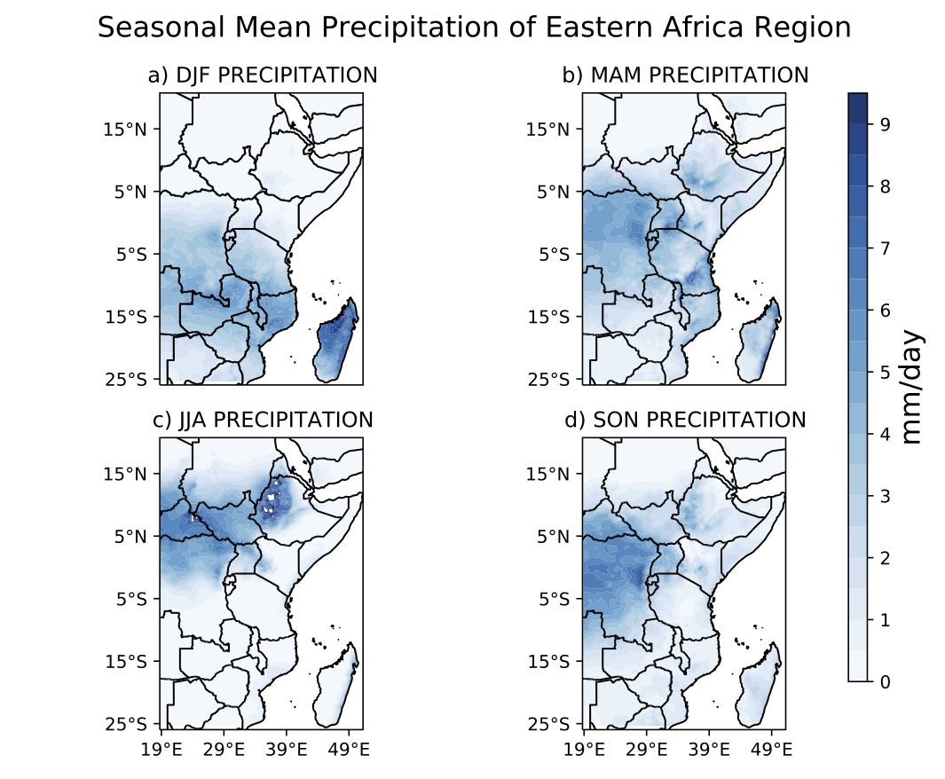
Figure [4] , indicates the distribution of yearly mean precipitation in East Africa. From the figure, we can see that there is precipitation received in most of the countries for the period under study. The Northern and eastern side of Madagascar, Eastern side of Ethiopia, Northern Mozambique, Rwanda, Burundi Uganda and Western side of Kenya records highest amount of precipitation received. The Northern Eastern side of Kenya, Somali, parts of Ethiopia, Eritrea,Djibouti, Zambia and parts of Tanzania indicate average to below average precipitation. However, the North side of Somali indicate no precipitation is received in the region. In Kenya, the central and the Western regions received highest precipitation while the rest of the regions indicates low amount. Figure [5], shows the different seasons across the East Africa region and the distribution of precipitation during the these seasons. During the DJF season, there is precipitation in the lower part of East Africa, with Madagascar receiving the highest precipitation in that season. Parts of Northern Kenya, Ethiopia, Somali and Eritrea do not record precipitation during the season.
During MAM (often called the “long rains”) season, almost all countries in East Africa receive average precipitation and more than average in some countries like Uganda and Rwanda. During JJA season, parts of western Kenya, parts of Ethiopia Susan and Eritrea, receive precipitation while all other countries, do not record any precipitation. During SON season, there is precipitation being received in most parts of the region. Uganda, Rwanda, Burundi, South Sudan and Madagascar receive the highest precipitation. Some parts of Kenya, parts of Tanzania and parts of Somalia receive no precipitation.
Dryness and Wetness Conditions
In this subsection, the analysis focuses on the consecutive dry days and the consecutive wet days experienced across the East Africa region. Consecutive dry days (cdd), is defined as the number of days that receive less than 0.1mm of rainfall in a row while consecutive wet days is defined as the number of days that receive precipitation that is at least 1mm in a row. The figures below show the patterns of the cdd and cwd in the four different seasons.
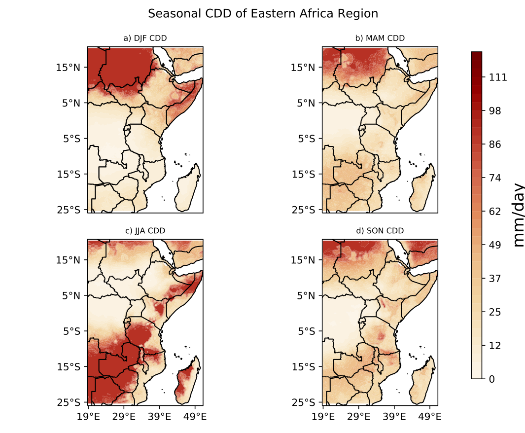
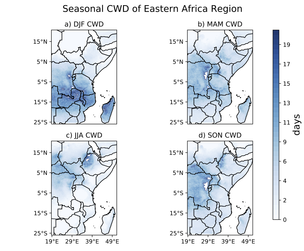
Figure [6] above, shows the four seasons and the amount of cdd in the different countries of the region. Comparably, figure [7] shows the cwd of the different seasons in the region. As it can be seen in the DJF season, the number of consecutive dry days are more in the northern part of the region that is, Somali, Djibouti, Eritrea, north part of South Sudan, part of Ethiopia. Following closely is Kenya whereby the north eastern region is leading. On the other hand, the wet days are more in the southern part of the region. Tanzania, Rwanda, Burundi, Mozambique and Madagascar receives the highest amount of precipitation. During the MAM season, it can be seen that there are minimal consecutive dry days across the East Africa region while the number of consecutive wet days higher than the previous season in all the countries. During the JJA season, western and central of Tanzania, north of Somalia, North Eastern Kenya, east part of Madagascar, Zimbabwe and Zambia experience the highest number of consecutive dry days. These areas have the least number of wet days during the season. This applies to the SON season. Whereby the number of dry days is below average with Uganda, Sudan and parts of Ethiopia having the least dry days. On the contrary, there are the regions that have the wettest days in the regions.
Conclusion
From the study, it can be seen that East Africa is a region that can be characterised by 4 different seasons. Since it lies along the equator, there are no extreme low-temperature conditions such as snow and winter seasons experienced. From the findings, we can generalise that Ethiopia, South Sudan, northern Kenya, Djibouti, Eritrea, Somalia and are adversely affected by dry conditions by comparing the consecutive dry days and the consecutive wet days. This results to them being the driest parts of the East Africa region.
References
[1] M. Collins, R. Knutti, J. Arblaster, J.-L. Dufresne, T. Fichefet, P. Friedlingstein, X. Gao, W. Gutowski, T. Johns, G. Krinner, M. Shongwe, C. Tebaldi, A. Weaver, M. Wehner, M. Allen, T. Andrews, U. Beyerle, C. Bitz, S. Bony, and B. Booth, Long-term Climate Change: Projections, Commitments and Irreversibility, ser. Intergovernmental Panel on Climate Change. United Kingdom: Cambridge University Press, 2013, pp. 1029–1136.
[2] C. C. Funk, P. J. Peterson, M. F. Landsfeld, D. H. Pedreros, J. P. Verdin, J. D. Rowland, B. E. Romero, G. J. Husak, J. C. Michaelsen, A. P. Verdin et al., “A quasi-global precipitation time series for drought monitoring,” US Geological Survey data series, vol. 832, no. 4, pp. 1–12, 2014.
[3] U.Schulzweida,“Cdouserguide,”Oct.2019.[Online].Available:https://doi.org/10.5281/zenodo.3539275
Leave a Comment